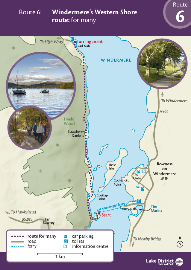
A tarmac road and smooth stone track lead you up the quiet west shore, a world away from the hustle and bustle of Bowness and Windermere - OS Explorer Map OL7
This is a linear route, 4.5km each way. The first 2km from Ferry House to Strawberry Gardens is a 'for many' route and the next 2.5km from there to Red Nab is 'for some'. (Please note, the map below has not yet been updated to reflect this split).
Once you've arrived at the Ferry House, follow the road around the headland for 400 metres and take the next right. Take care on this stretch as it can be busy in the summer. A public footpath does cut off this loop but it is not suitable for wheelchairs or those with buggies. Just after this turn you reach the entrance to Claife Station Courtyard. This is a great spot for a picnic and a different path (only suitable 'for some') here also leads up to the viewing station built in 1790 with fantastic views over the lake.
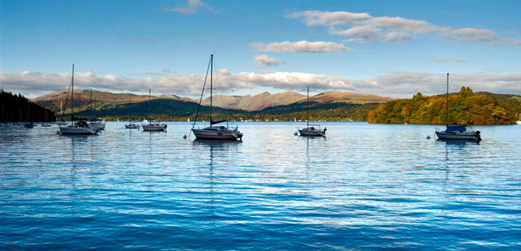
The first kilometre is tarmac and it weaves through woodland and open meadow. Be aware of traffic heading along this section to the car park and to the caravan site further up the shore. The views are expansive, looking across the lake to Bowness and further north to the Troutbeck hills. The western shore provides a wooded shoreline and pebble beaches. There is plenty of scope to rest and picnic.
The tarmac ends by the second of two cattle grids and you pass into Heald Wood on a level stone track. This has been substantially improved through the GoLakes Travel Programme and is now suitable for wheelchair users. The 'for many' route ends at Grid Ref. SD 38790 97018, near Strawberry Gardens caravan site, so visitors requiring that standard of route will need to turn around here and head back to the start.
The route continues at 'for some' standard, past Strawberry Gardens on a good stone track (with some sections of steeper gradient up to 1:6) all the way to Red Nab (and the start of Route 7). You can combine this walk with Route 7 Red Nab to High Wray for a long expedition to Wray Castle and back.
Postcode: LA22 0LP
Grid reference: SD 39085 95703
W3W: ///treaty.stormed.hamster
Grid reference: SD 38790 97018
W3W: ///includes.direct.fruitcake
Postcode:
Grid reference: SD 38563 99369
W3W: ///country.elaborate.scrolled
Toilets at Ferry Nab and Ferry House. Refreshments at Bowness and Claife Station Courtyard Café (no toilets)
Public transport: Cross Lakes Experience, taking the boat from Pier 3, Bowness or the 525 Mountain Goat bus service from Hawkshead (please note this service has been suspended for 2022). The car ferry from Ferry Nab can also be used.
Car: take the ferry and park in the National Trust car park at grid ref. SD 388960.