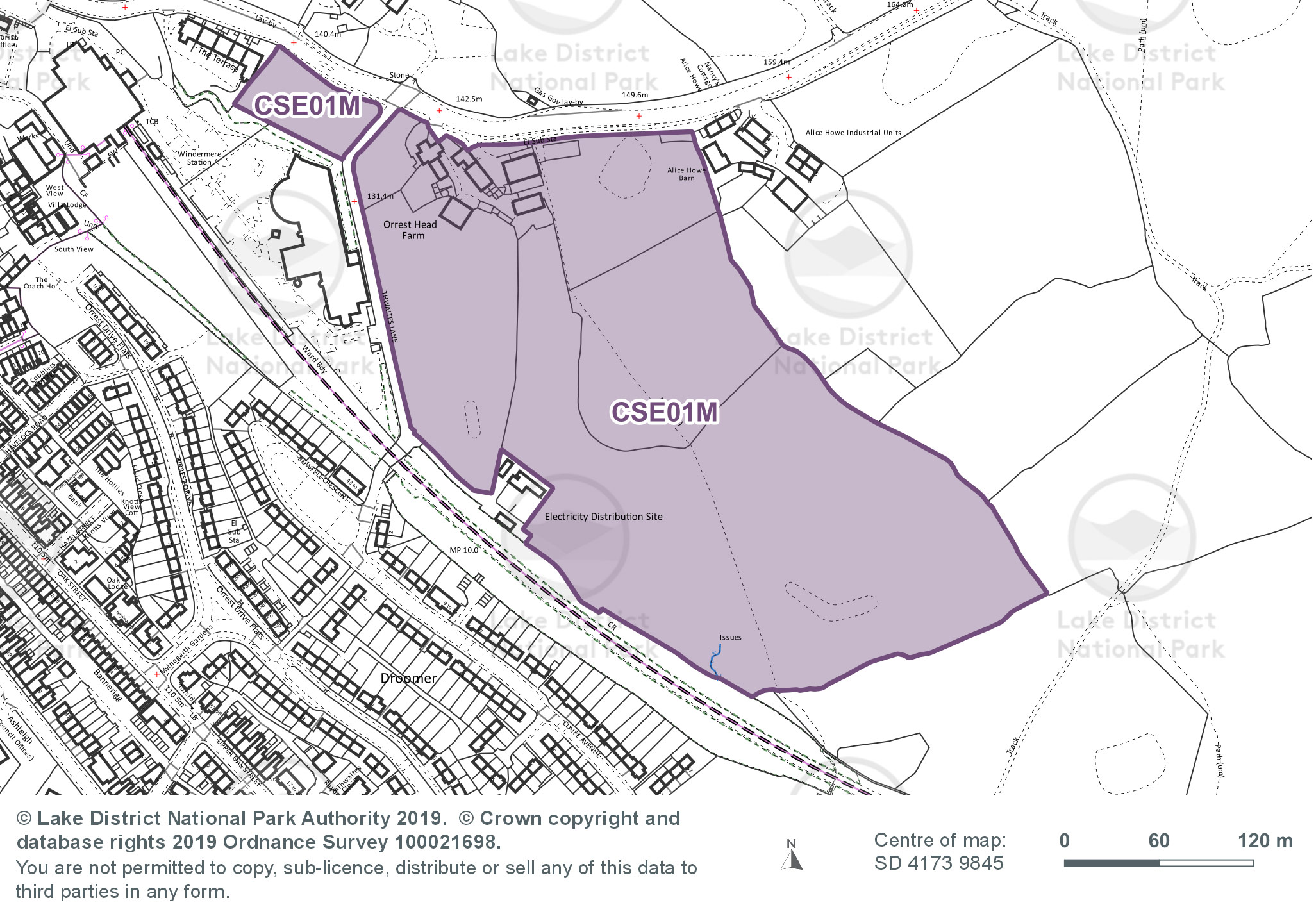
Site area (hectares): 9.05
Use: Mixed - housing, employment and tourism uses
Site requirements:
- Submission of a Screening Opinion to guide the production of an Environmental Statement.
- Transport Assessment and Travel Plan would be needed. Junction modelling will be required.
- New junction alignment/roundabout provision together with road widening and footways on Thwaites Lane are required. Ensure consideration is given to Orrest Head House junction, and this is incorporated into any roundabout proposals if located in the proximity to this junction.
- Safeguard smaller parcel of land adjacent to 'The Terrace' from development other than for access improvements and to ensure a buffer between the listed buildings of The Terrace to protect their setting. This buffer will need to form part of the landscaping scheme.
- The development should be connected by sustainable transport to surrounding areas so that it increases the attractiveness of walking and cycling. Opportunities should be taken to link to the adjacent cycle network, and to public rights of way to the town to the south, and Orrest Head viewpoint to the north.
- Development proposals will need to respect the setting of the listed farmhouse and stone buildings. Discreet high quality development is required in the immediate surrounding of the Listed Building.
- Heritage Impact Assessment to assess the impact on World Heritage Site designation and heritage assets. In addition a Heritage, Design and Access Statement and a World Heritage Site Checklist would be required.
- The design characteristics of the wider Windermere Conservation Area should also be taken into account.
- The scale, design, and layout of development will be key considerations particularly with reference to the neighbouring residential properties.
- Ensure design works with topography and cultural heritage features to sensitively integrate into landscape. The layout should seek to conserve interesting landscape features, including rocky outcrops, single and clusters of trees, and stone walls.
- An extended Phase 1 Habitat survey is recommended to establish potential ecological constraints to development and to identify opportunities for enhancement.
- A bat survey may be required as part of any future development proposals to allow for the development of appropriate mitigation measures if required.
- Trees will be retained and appropriate root protection areas will be required of approximately 12-15m the larger trees.
- Flood risk assessment required as site is over 1 hectare.
- The layout and the sustainable drainage systems should be designed to mimic natural drainage flow paths by utilising existing natural low lying areas and conveyance pathways.
- Any development must be protected from surface water flooding and must not displace flood water elsewhere.
- The siting and density of any development, particularly in the elevated northern parts of the site, should conserve key views to the lake from A591 and retain a sense of openness with properties at Alice Howe.
- Care will need to be taken to maintain a connection with the wider landscape and avoid interrupting views across Windermere to the lake for example due to large scale vertical elements.
- Foul flows only to be discharged to Public Sewer Network, connection points to be confirmed with United Utilities.
- Where appropriate and agreed with the relevant authority, divert overhead lines and underground cables.
- The closure of the level crossings Droomer No.1, Droomer No.2 and Droomer No.3 are stopped up and diverted as far as is physically possible to rationalise the relevant pedestrian level crossings so as to provide safe and continued access by new means or routing to be agreed with the relevant authority.
- Ensure site infrastructure delivers broadband of at least 30Mbs for employment uses. This includes providing fibre broadband within the site to ensure connection to ‘Fibre to the Premises’ (‘full fibre’) when it becomes available.