![]()
A fairly strenuous linear route that leads high up into the hills above Grasmere. The gradients are occasionally steep, and the track is rough in places. A footbridge at the entrance to the moorland and uneven ground at the Scheduled Monument at the top make the route unsuitable for wheelchair and pushchair users. Approximately 60-70 minute walk.
OS Explorer Map: OL7
Distance: 5 km, 3 miles
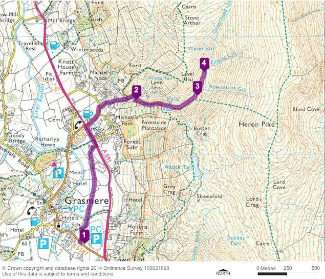
Start point: LDNPA Stock Lane car park, Grasmere - grid ref. NY 339 073
Turning point: Greenhead Gill Lead Mines - grid ref. NY 349 087
Facilities: Toilets at Stock Lane LDNPA Car Park. Disabled toilets in Grasmere and also at Dove Cottage. Refreshments available in Grasmere and also at Dove Cottage.
Getting there: Bus: 555 and 599 services operate regularly to Grasmere from Ambleside and Keswick. Car: take the A591 from either Ambleside or Keswick.
The Car Park is Audio Stop Point 1. The trail route then leads north along a footpath from the Stock Lane car park up to the A591.
The route follows the A591 north to the Swan public house. Turn right up the road before the Swan public house and follow the small road, taking the left fork, up the hill. Take the footpath off this road which leads to a gate leading onto the fell by a bridge.
Once through the gate the path doubles back over a footbridge and follows the stream uphill on the right hand side. The narrow footbridge and the steep, narrow, uneven path following this are unsuitable for either wheelchairs or pushchairs.
After a steep climb that follows the stone wall on the right there is a bench overlooking a bridge across the stream deep down in the Gill. This is Audio Stop Point 2, at NY 344 084.
Follow the route uphill again. Don’t take the path which heads right towards Dove Cottage or the path after this which leads steeply uphill towards the summit of Heron Pike. Instead follow the gently rising path alongside the gill which curves around to the left as the gill does. Audio Stop Point 3 is at Rowantree Gill, at NGR 349 085.
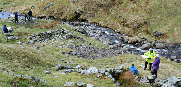
The path continues through the Greenhead Gill Lead Mines Scheduled Monument. It follows Greenhead Gill along a gentle uphill slope across rough ground unsuitable for either wheelchairs or pushchairs, past the surface remains which survive from the Elizabethan and Victorian Lead Mines. Audio Stop Point 4 is just before Grains Gill, at NGR 349 087.
Once you have listened to the audio and explored the site you return back down the way you came.
This map is only indicative of the route. Please take a map with you – Ordnance Survey Explorer OL7 – to be sure of the route you are taking.