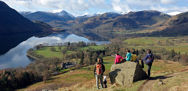
The Ullswater Way is a 20 mile walking route that goes around the whole of Ullswater lake. You can do the walk in one go, or do a smaller section combined with a boat trip or bus ride. There are villages and eating places along this fairly low-level, easy to walk route, making it ideal for all ages.
Join us on our video to see some bits of the route and some of the spectacular views.
Then download the route maps and start planning your walk!
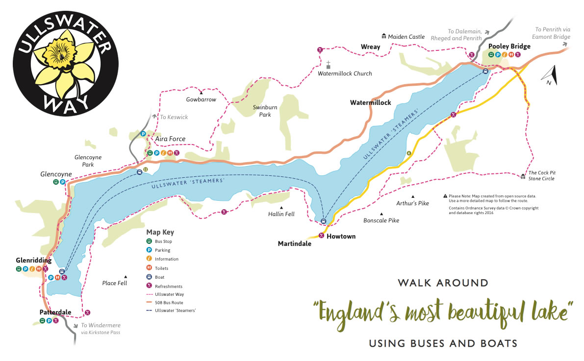
The full Ullswater Way is 32 km / 20 miles, but there are plenty of ways to do a shorter section in a day and then get the bus or boat back to your starting point.
Ullswater Steamers - boat stops and timetable
Ullswater Bus - bus stops and timetable
You can also buy The Ullswater Way - Offical guide, which contains all the route maps, and useful tips on where to park, eat and catch the boat or bus. The guide is available at the Ullswater Information Centre and many other local shops.
Once you've walked the route, pop into one of the shops around Ullswater to pick up your badge. The Ullswater Information Centre at Glenridding has them too!
The Ullswater Way follows a combination of Public Rights of Way and short sections of quiet roads. There is one section at Stybarrow Crag where you will walk along the side of the A592. This is for a total of 200m – please take care on this section.
The terrain on the Ullswater Way varies, from fell paths and tracks, undulating sections through woodland, and agricultural fields where you may encounter livestock. The surfaces vary with some grassy paths, gravel tracks and on the optional Gowbarrow route some steeper stone paths. For more information on walking in the Lake District and the likely hazards you may encounter see our walking webpage Walk safely : Lake District National Park
Accessibility: The majority of the route has gates for ease of access, however there is one stone step stile on the lower route between Howtown and Pooley Bridge – this is avoidable by using the higher route via Askham Fell.
There are some sections which are suitable for those who are less able – such as along the lake shore from Pooley Bridge to Gale Bay (Miles without Stiles route: Pooley Bridge to Gale Bay – put in link), and the route from Aira Force to Glencoyne which is a surfaced, relatively level path through Glencoyne Deer Park. Another section which may be suitable for more all-terrain mobility vehicles is the route from Roehead on to Askham Fell, subject to assessment by individual users as to suitability.
Walking the Ullswater Way is a challenge. So is taking care of its surrounding footpaths.
The path welcomes thousands of visitors each year. We need your help to maintain, protect and care for this much loved path.
Donate to the Lake District Foundation to help look after the Ullswater Way


