Updated: 13 April 2021
2024 Tilberthwaite Survey Update
The first meeting of the Tilberthwaite Partnership Management Group took place on 25 March 2021, following the recommendation of the Rights of Way Committee in October 2019. Initial plans were postponed in order to allow the Judicial Review to take place, see below.
The Tilberthwaite Management Group includes representatives from user groups, landowners, statutory bodies and the local community.
The purpose of the group is:
To steer and monitor a collaborative approach to the establishment and proving of a long term sustainable management regime for the unsealed section of U5001 public road (High Tilberthwaite to Fell Foot).
The first meeting on 25 March was well attended by those suggested for invitation by this committee. The Partnership Group agreed upon their remit, which aligns closely with that suggested by this committee. The next meeting will be held on 21 June 2021, at which the group will begin to discuss the future monitoring and management of the road.
On 21 August 2020 the Honourable Mr Justice Dove dismissed the Green Lanes Environmental Action Movement’s application for judicial review. The Judgement dismissed the claim on all three grounds; supporting and vindicating our approach to the Sandford principle, our approach to the survey and consultation, the manner in which the matter was presented to committee and the decision reached.
On 8 October 2019 the Authority agreed that Tilberthwaite Road (U5001) should be maintained in its current condition by our partner Cumbria County Council and that we create a partnership management group of invited key partners and stakeholders to work collaboratively to monitor usage and condition; undertaking necessary activities to help mitigate any new issues that may arise. And for the High Oxen Fell Road (U5004), again Cumbria County Council maintains the road surface at its current condition, and we work with them and the National Trust to monitor surface condition.
Prior to the application for judicial review by GLEAM we were looking to bring together, in early 2020, the various interested parties to form a management group (for U5001). This group would operate through consensus and its membership would steer and monitor a fully collaborative approach to the establishment and proving of a long-term sustainable management regime for the unsealed section of the U5001 public road (High Tilberthwaite to Fell Foot). The activities of such a task and finish group could include - continued monitoring of use, attitudes, surface condition. It would also look to ensure appropriate maintenance is provided and would contribute to development of a project that tests and agrees at a point in time the adequacy of the management approach for the road.
Given the judicial review we felt it was inappropriate to form the management group prior to the judicial review being determined. And since that time we have had to focus our attention on managing the national park in light of the needs and impact of Covid-19. In this context we need to review the timing and formation of the group to ensure we deploy our resources to the highest priorities across the park and make sure that such a group can work effectively in partnership. Given monitoring of the route use and its condition is on-going and our focus on general visitor management is necessary - it is likely we will look to establish the working group early in 2021.
The Judicial Review decision can be found here.
At the Rights of Way Committee on 8 October 2019 members discussed the reports and associated papers. Please take a look at the summary below.
These routes are both public roads, partly tarmac and partly unsealed. As such pedestrians, horse riders, cyclists, motorcyclists, and motorists can use their whole length. The roads were originally well-built stone roads that served agricultural and quarrying activities and, as such, form part of the historic heritage of the area.
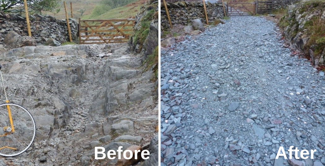
During the past 20 years or so, motor vehicular usage of both these roads has increased. At the same time, minor maintenance of the surface and drainage appears to have declined, and there have been at least three severe weather incidents (2005, 2009, 2015). The combination of all this has led to a deterioration in the surface of the Tilberthwaite road in particular, to a degree where some agricultural traffic was having difficulties in accessing the land for farming purposes.
In 2017 we initiated a project to look at the future management options for these two unsealed roads. We are delivering this project in conjunction with Cumbria County Council and the National Trust (who own the farms and surrounding land).
The Tilberthwaite road has been repaired, and the surface subsequently monitored. We have collected evidence through drop-in sessions, online and onsite surveys, as well as collating data on usage levels.
There are three parts to the report that were taken to committee - please click on the buttons to read the reports. For a short summary of the project so far, please read the Frequently Asked Questions below.
Committee Appendices (if on mobile, click through to 'continue to website')
The Appendices totals more than 1000 pages (and reports). This link will take you to a Dropbox account. All documents can all be downloaded, even if you do not have a Dropbox account.
A paper copy is also available for any member of the public to inspect, this is held by the Contact Centre at our offices in Murley Moss, Kendal. It is advisable to arrange a time to visit before arriving by phoning
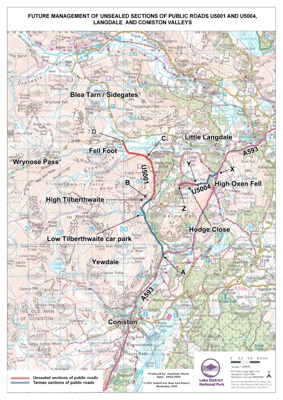
The two roads are shown on the map below in red and blue:
They are both public through roads, with around half of their length being tarmac, and half being unsealed, that is: not tarmac covered. Both tarmac and unsealed sections are covered by the same highway legislation as other public roads such as the A593 or Wrynose Pass. They are maintained by Cumbria County Council. Although the National Park has no legal responsibility to maintain these roads, we recognise their importance as part of the overall rights of way network that people use to enjoy the national park. The roads are part tarmac, and part unsealed, however, we are being requested to restrict motorised traffic only on the unsealed sections of these two roads.
In the Lake District National Park, there are some 3280km of public unsealed minor roads, byways open to all traffic, restricted byways, bridleways and footpaths. There are legally established, or presumed, motor vehicle rights on around 121km of these.
The unsealed section of the Tilberthwaite road is 2.5km, whereas the unsealed section of the High Oxen Fell road is 0.59km long. The combined length of around 3.1km of road is approximately 0.1% of the unsealed linear network.
Photos shows part of the Tilberthwaite road before and after the maintenance work was completed in January 2019.