Larger version of Wasdale Head photo (PDF)
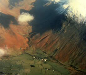
This is a typically dramatic Western Lake District landscape showing the flat valley bottom at the head of Wasdale. The photo shows Wasdale Head with the pub, hotel and Row Head Farm. The valley has only one road in and out, it is in effect a dead end; it contains Wastwater, which is England’s deepest lake (74m).
The nearest primary school is Gosforth CE School, 9 miles away, and the nearest town is Egremont, 13 miles away, which also has the local secondary school, Wyndham. There is a campsite at the northern edge of Wastwater just out of the photo. England’s smallest chapel is one of the white buildings in the middle of the fields in the valley bottom. The famous fellrunner Joss Naylor comes from the Wasdale valley.
The snow-covered mountains are indeed more than hills, since at 628m (Yewbarrow on the left) and 802m (Kirk Fell slightly out of the photo on the right), they are both over 600m. Mosedale Beck runs down the fellside in the middle of the picture, while Lingmell Beck flows right to left in the foreground. Lingmell Beck shows examples of both stream braiding and a meander. The vertical lines running down the flanks of the fells in the photo are caused by water run-off on land with little vegetation. The mountains in the photo are volcanic in origin and are the outcome of glaciation during the last Ice Age which ended about 10,000 years ago.
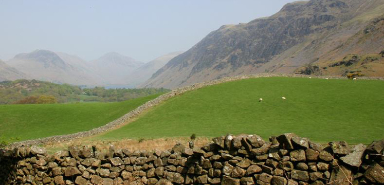
The photo shows how dry stone walls are used to divide up the farming landscape. The fields around the farm in the valley bottom are known as in-bye fields, whereas the fields up the fellside have been ‘taken’ from the fell and are known as in-take fields. The land above the highest wall is therefore the open fell.
Wasdale is the main access point to England’s highest mountain, Scafell Pike (978m) and sits at 80m above sea level. The snowy conditions in the scene suggest the photo was taken any time from November through to April. The orange/brown vegetation is bracken, a fern which has grown up in areas where trees would once have been. The shrubs near the river in the foreground are gorse.
Many of the older Cumbrian buildings are white because houses and farms used to be treated with red lead and then lime washed, which whitens, to keep out the damp. Many homeowners today have perpetuated the tradition of painting their houses white.
Grid reference of Wasdale Head: 187088 (English Lakes SW 1:25,000)
meander, scree, hamlet, valley bottom, dry stone walls, fell, mountain landscape, beck, braiding
What jobs/leisure pursuits might the people who live there have?
How far do you think it might be to the nearest school or town?
Why is there cloud in the middle of the valley?
Why is there snow only on the fell top?
Why would tourists come to this mountain area?
What would you expect the climate to be like in this mountain area?
Where does the road go to?
Choose 2 unusual features from the picture to talk about.
Talk about the streams that you can see in the photo.