There are a wealth of stone circles and stone age remains across the Lake District. These are four of the most prominet stone circles that are all free to visit. Each one has a unique atmosphere, all of them still have a mysterious purpose.
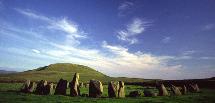
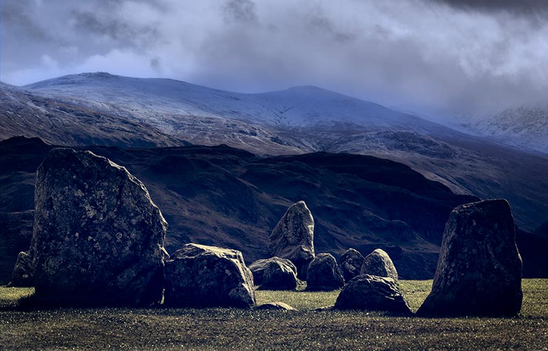
This is a famous monument in a dramatic location, surrounded by mountains. The main circle has 38 large stones, some standing 3 metres (10 feet) high. The entrance seems to line up with the midwinter sunset. This neolithic monument is one of Britain's earliest stone circles, about 5,000 years old, and has been officially protected since 1883. However it gets so many visitors that conservation is an everpresent concern! Managed by the National Trust and English Heritage, Castlerigg Stone Circle is free to visit during daylight hours.
Location: North Eastern Lake District, near Keswick.
Grid ref NY291236. 2.5 kilometres (1.6 miles) south east of Keswick off the A591. Limited parking near site.
High above Ullswater, the windswept upland known as Moor Divock is scattered with prehistoric monuments. The Cockpit is one of the most impressive. It's a circular stone bank, 27 metres (90 feet) across, with larger stones set into its inner face. Like all stone circles, its original purpose is a mystery. It may have been for rituals and gatherings, or a sign of land ownership.
Location: North Eastern Lake District, near Pooley Bridge at the north end of Ullswater.
Grid ref NY482222. 3.5 kilometres (2.2 miles) south west of Askham. Fairly steep walk from Askham or Pooley Bridge.
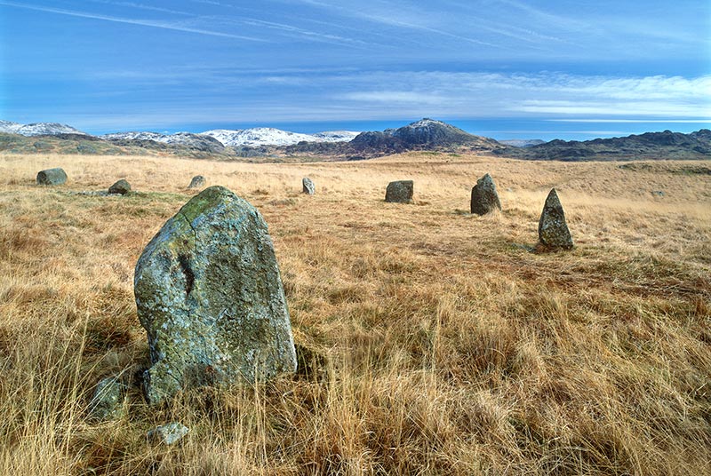
This little-visited stone circle is one of the finest in Britain. It has 55 stones, up to 3 metres (10 feet) high. Like Castlerigg, it dates from the Neolithic period and its entrance seems to line up with the midwinter sunset. Its other name, Sunkenkirk, comes from a legend that people tried to build a church here, but the Devil kept pulling it down.
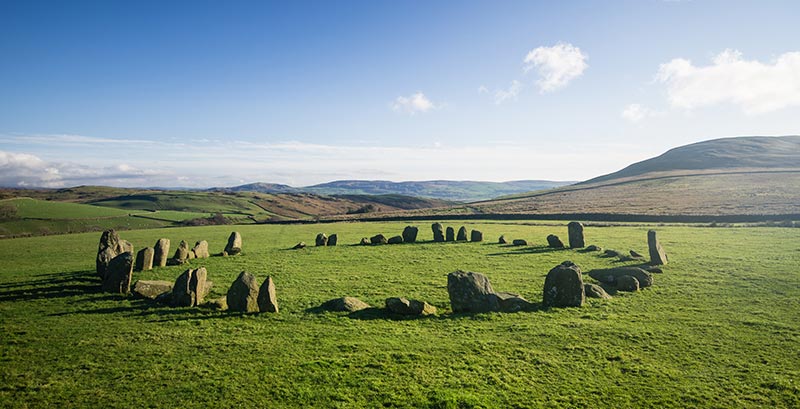
Location: South Western Lake District, near Broughton in Furness
Grid ref SD171881. 4 kilometres (2.5 miles) west of Broughton in Furness, turn off A595 at Broadgate. Parking at start of track, then 1.5 kilometres (0.9 mile) walk.
These five separate stone circles, perched on high moorland, date from around 2000 BC. They all contain at least one burial, marked by a stone cairn. Were they ritual monuments, meeting places or a mark of ownership? Perhaps all three. Nearby are stone banks and other cairns, which may be more recent. The whole site covers more than 2.5 square kilometres (1 square mile). Managed by the National Trust.
Location: Western Lake District, near Eskdale.
Grid references NY172028, NY172027, NY172023, NY172024, NY173023.
Burnmoor, above Boot. Parking at Dalegarth Station. Strenuous walk from village. The nearest and largest circle, Brat's Hill, is on your right.
You’ll easily spot this burial mound on Askham Fell. Standing 1.8 metres (6 feet) high and 22m (72 feet) across, it’s the most visible of a clear line of cairns and standing stones. Excavations in the nineteenth century found human remains in a stone-lined grave inside the cairn. Stone burial mounds are typical of the uplands in the Bronze Age.
Location: Grid ref NY488224. 2.7 kilometres (1.7 miles) south west of Askham. Fairly steep walk from village.
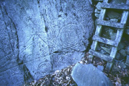
These mysterious carvings are up to 6,000 years old. There are circles, lines, ‘cup’ marks - small hollows in the rock - and other abstract shapes. Some of the ‘cups’ are natural but have been incorporated into the design. Archaeologists think they may have been a way of showing links between people and important places. Managed by the National Trust, the rock carvings are free to visit.
Location: Central Lake District, in Langdale.
Grid ref NY313058. Beside B5343 in Great Langdale, 250 metres south of Harry Place Farm. Limited parking in Chapel Stile.
Though there’s not much to see on the ground, this area is rich in burial mounds, standing stones and possible hut circles. Archaeologists excavated some of the cairns in the 1950s and found jet beads, a flint knife, an arrow-head, and pottery typical of the Bronze Age. You can see the beads and other finds in Tullie House Museum and Art Gallery, Carlisle.
Location: Western Lake Distirct, near Gosforth.
Grid ref NY125020. 5.5 kilometres (3.4 miles) south east of Gosforth via Santon Bridge. Parking at start of footpath.
There are three farmsteads here which date from Roman times, but reflect an older, local way of life. Each farm contains hut circles and animal pens, enclosed by parallel banks and a ditch. Outside lies a sprawling complex of fields of various shapes and sizes. Some of the boundaries are obvious, but the full extent of plots and connecting tracks can be seen only through aerial photography.
Location: North Lake District, near Uldale
Grid reference NY264381. Near minor road between Uldale and B5299. Roadside parking 2 kilometres (1.2 miles) north east of village, then short walk on bridleway.
This was a substantial farmstead, with seven circular stone huts, a well, livestock pens, fields and two trackways linking it all together. At the edge of the fields are about 50 cairns, probably the result of preparing the land for farming. People may have lived here from the late Bronze Age right through to Roman times, with little change in their way of life.
Location: North Lake District, near Keswick.
Grid ref NY327239. 1.5 kilometres (0.9 miles) south of Threlkeld. Car park at Birkett Mire, just off B5322. Permitted footpath along old railway track to bridge. Follow road up to gate and take path around east side of Threlkeld quarry.
You won’t see any archaeological remains here, but the past is written in the landscape. Pollen samples from the bottom of the tarn show that some of the forest disappeared between 3700 and 3100 BC, but grew back 1000 years later. It seems that people were clearing trees to make way for grazing or farming, but were not staying permanently in the same place.
Location: Grid reference NY293044. Near minor road off A593, 8.5 kilometres west of Ambleside. Parking is a short walk from the site.

Created with support from the Heritage Lottery Fund