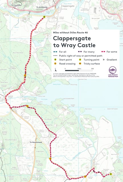
Warning 28 March 2024: There are two issues on this route currently, which we are working to repair shortly. There is a washout at Grid Ref NY36302 03009 (about 500m from the start of the route near Clappersgate) and a wall which has collapsed on to the path at Grid Ref NY35966 02183 (just before you reach the road near Pull Wyke in the middle of the route). Both narrow the route to 500mm, so are not passable by most wheeled equipment.
For some. Undulating, with several steep sections. This linear path (4km each way) provides a lovely walk along field edges and through woodland all the way to the National Trust's Wray Castle on the shores of Windermere - OS Explorer Map OL7. Be aware there are two road crossings and one 150 m section where you are either on a narrow pavement or on the road itself.
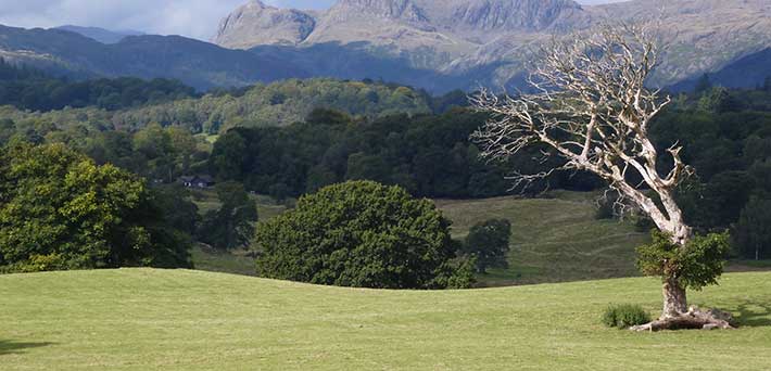
From the car park, follow the wide, smooth stone path hidden behind the wall that runs parallel to B5286 Hawkshead road and that is signposted with a blue National Cycle Network no.6 sign saying Bowness via Ferry. The whole route follows the Route 6 cycle way, which is well signposted. Take time to look back over your shoulder and you’ll see the Holy Trinity church at Brathay on a knoll with Loughrigg Fell in the background. The Italianate style church dates from 1836 and was built by the Redmayne family of Brathay Hall.
After about a kilometre cross the road and up a short steep ramp beside a bus stop onto the path again. After 100 metres you descend to the road again and for the next 150 m carefully use the narrow pavement (0.75 m) beside the road. A gap in the wall on the left provides access to some steps back onto an off-road path. For a step-free alternative, carefully follow the on road cycle path for another 25 metres to another wall gap that also leads back onto the path. Then follow the path initially downhill and the uphill, taking care at a stone clad culvert. At the top of the hill turn left and follow the path that runs parallel to the Pullwood Bay driveway. After 250 metres, the path crosses the driveway and then continues uphill, winding through some beautiful woodland.
After going through a gate to leave the woodland, go downhill to meet the minor road to Wray Castle. Cross the road and onto the path again that runs parallel to the road. Keep following signs for Wray Castle until you come out onto a road opposite the entrance to Low Wray campsite. Cross the road and follow the campsite road but just before you reach a set of historic farm buildings turn right up the hill sign-posted Castle. Follow this path up the hill, at the top turn left onto the castle’s driveway and after 100 metres you’ll reach this splendid mock-Gothic castle which has extensive grounds to explore.
Parking in a layby opposite Brathay Hall entrance off the B5286 Hawkshead road.
Postcode: LA22 0HR
Grid reference: NY 365033
W3W: ///pushing.spoiled.apartment
Grid reference: NY 375010
W3W: ///charging.owner.superbly
Wray Castle (seasonal: check opening times on National Trust website) Café, shop and toilet accessible by wheelchair users and with baby changing facilities.
Bus: The 505 bus from Kendal, calling at Windermere rail station and Ambleside will take you to opposite Croft House on the A593 just before Clappersgate. From the bus stop you will have to walk on a short stretch of the Hawkshead road with no pavement for 300 metres from Clappersgate to the start of the off-road path.
Car: A593 from Ambleside, then turn left B5286 signposted to Hawkshead. Car-park 300m on left at junction with Bog Lane.
By foot: From Ambleside walk 1.5 km along the shared use pavement beside the A593 Coniston road. But then you will have to walk on the Hawkshead road for 300 metres to reach the start of the off-road path.