![]()
Description: A gentle circular route that leads across Elterwater Common to Low Wood. The route turns back to the start point at High Close, leading down Elterwater Common with views across to the Langdales. The trail follows the main road and woodland paths which become steep as you reach the impressive High Close. The trail leads to the remains of a water mill in Low Wood. The gradients are mostly gentle and the track is mostly good. There is one difficult stile at the entrance to Low Wood and a section of woodland track at the water mill which are both unsuitable for wheelchair or pushchair users. Approximately 50-60 minute walk.
OS Explorer Map OL7
Distance: 3.2km
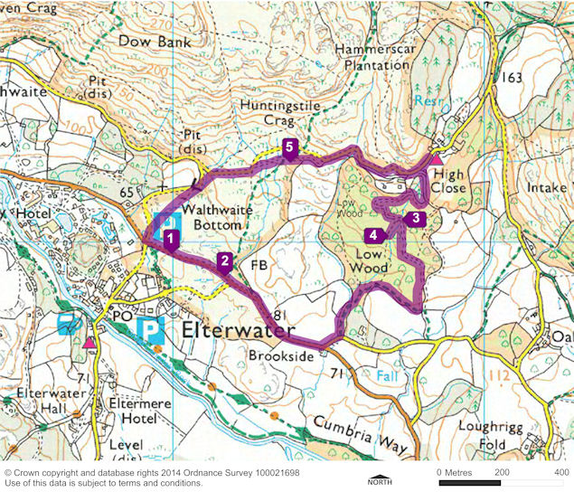
Start: Elterwater Common car park (Grid ref. NY 330 050)
Turning point: High Close (Grid ref. NY 338 052)
Facilities: Toilets at Elterwater. Disabled toilets at Britannia Inn, Elterwater. Refreshments at Britannia Inn, Elterwater and at High Close YHA.
Getting there: Bus: Langdale Rambler service 516 runs from Ambleside to Elterwater, March to October. Car: A593 from Ambleside or Coniston and turn at Skelwith Bridge on the B5343. It is 2.5km to Elterwater.
The Car Park is Audio Stop Point 1. The route leaves the car park along the road heading south towards Elterwater and the crossroads with the A593.
The trail route then heads left at the crossroads, following the A593 east towards Skelwith Bridge. Audio Stop Point 2 is in the layby at NY 331 048.
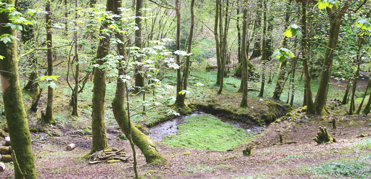
The trail continues east along the A593, over the cattle-grid. After about 500m follow the first road to the left. The stile entrance to Low Wood is on the left-hand side at the first bend; this is unsuitable for either wheelchairs or pushchairs. Follow the path into the woods and after taking the right fork skirt around the edge of Low Wood. The small woodland path joins into a track as the trail heads north. The track bends to the left, then to the right as it overlooks a shallow dell. Audio Stop Point 3 is at the bridge which crosses over the stream, at NY 337 050. This is the site of the water mill.
The trail continues along a rough track south, past the mill pond and the other remains. The rough ground here is difficult for either wheelchairs or pushchairs. Audio Stop Point 4 is about 65m south of the bridge, at NY 336 049.
The trail returns back up to the main track. The track leads through the woods and eventually out through a gate onto the road. The High Close Youth Hostel is a short distance along the road to your right. Turning back from High Close the road brings you back down over a cattle-grid onto Elterwater Common. Audio Stop Point 5 is just off the road at Huntingstile Crag, at NY 334 052. The road leads back down through Elterwater Common to the car park at the start of the trail.
This map is only indicative of the route. Please take a map with you – Ordnance Survey Explorer OL7 – to be sure of the route you are taking.